How to Access a Live National Weather Radar Map for the USA
When you need to know if a storm is heading toward your commute, a garden project, or a weekend hike, a live national weather radar map for the USA gives you the most immediate picture of precipitation and movement across the country.
What does a live national weather radar map show?
A live radar map displays real‑time echoes from precipitation—rain, snow, or hail—as they are detected by the network of NEXRAD stations operated by the National Weather Service. The map updates every few minutes, showing where moisture is falling, how intense it is, and which direction it is moving.
Why is up‑to‑date radar valuable for everyday decisions?
For a value‑focused buyer, timing matters. Knowing whether a thunderstorm will hit a construction site in the next hour can prevent costly delays and protect materials. Home gardeners can avoid watering just before a downpour, saving on water bills. Commuters can choose alternate routes when radar shows a line of storms approaching a highway.
Where can you find a reliable free radar map?
The National Weather Service’s own website offers a national radar mosaic that combines data from all NEXRAD sites. Weather apps such as the NOAA Weather Radar Live, RadarScope’s free tier, and many local news stations also provide the same feed without subscription fees.
How to read the colors and motion on the map
Radar returns are color‑coded: light green indicates drizzle, yellow to red shows moderate to heavy rain, and pink or white often marks hail. Arrows or looping animations illustrate the storm’s trajectory, letting you estimate arrival time at a specific location.
Practical tips for using radar in planning
- Check the map 15‑30 minutes before heading out; updates are frequent enough to capture fast‑moving cells.
- Zoom to your city or county to see local intensity while keeping the national view for larger systems.
- Combine radar with short‑term forecasts; radar tells you what is happening now, while forecasts indicate what may develop later.
- If you see a red cell moving toward your area, consider postponing outdoor work or securing loose items.
Limitations to keep in mind
Radar detects precipitation, not clouds or temperature, so a clear radar does not guarantee sunny skies. Ground clutter or anomalous propagation can create false returns, especially over mountains or near large bodies of water. Always treat radar as one tool among many.
When to rely on radar versus a full forecast
For immediate, hour‑by‑hour decisions—like whether to pour concrete, schedule a roof inspection, or launch a boat—live radar is the go‑to source. For planning days ahead, rely on forecast models that incorporate radar data along with atmospheric modeling.
Staying informed without extra cost
By bookmarking the NWS radar page and setting a phone widget to refresh every five minutes, you get live updates at no charge, helping you protect investments and stay safe.
How To Build A Wood Floor Over Concrete | Floor Roma

subfloor install flooring hardwood installing sleeper slab basement sub
How-to Install A Wood Subfloor Over Concrete | RONA
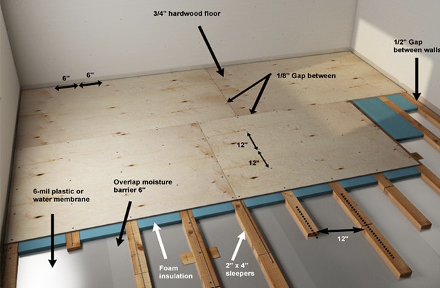
subfloor concrete wood install floor slab over how hardwood basement sleepers sleeper insulation construction membrane foam or
Installing Wood Flooring Over Concrete (DIY)

concrete flooring install installing engineered tongue groove